BANGOR
MONASTERY : DEDUCTIONS
AND ASSUMPTIONS - Part 1. |
| From an Article by Local Historian Derrick
Pratt. First published by the Bangor-on-Dee Local History
Society 1992. |
| Considering how much has been written about
it, surprisingly little is known about the early Welsh church
in Bangor. In 1988 a lecture given to Bangor Local History
Society broke new ground in that it significantly re-interpreted
existing 'evidence, asking listeners to turn from the traditionally
Romantic views of a Celtic seminary and church on the banks
of the Dee and to consider in its stead a 'monastic city that
may have played a pivotal role in the development of the Welsh
town. |
| In each of the previous issues of this magazine,
reference has been made to Bangor's monastery. This
is not surprising as, apart from its being the seasonal Mecca
for National Hunt race-goers, the great seventh-century religious
house is possibly Bangor's only real claim to fame and historical
legitimacy. The ancient association is still recalled
by a scatter of place-names, most of doubtful pedigree: Abbey
Walk, Abbeygate, Monk's Walk, Monk's Oak etc. |
| Considering the period when the monastery
flourished - sub-Roman in many respects - and the relatively
short time-span of its working life, concrete evidence relating
to Bangor is minimal. Local historians have arrived
at the point where they can only retread already well-worn
paths in their investigations of tired facts of doubtful authenticity. |
| However, in October 1988, prompted by an
article written ten years earlier by Professor L.A. Butler
of York University [1]
perhaps better known in the Wrexham
area as the excavator of Valle Crucis Abbey claustral buildings
in 1970, I was persuaded to radically re-assess the history
of Bangor Isycoed in the Dark Ages. The interest aroused
was such that the lecture was immediately earmarked for inclusion
in this journal. One little thought that within two
years Bangor Local History Society itself would fold and that
this is the valedictory issue of its magazine. In the
interim the lecture has also been given to Civic Societies
and Extra-Mural/W.E.A. classes at Wrexham, Hanmer and Llansilin,
making for a further crystallization of thought and consolidation
of ideas. |
| In what is essentially yet another permutation
of the few known and established facts, what is the new line
of approach? Basically it is to look at Bangor not so
much from the view of a Celtic monastery of some renown but
rather as a rare phenomenon for the period - a hitherto unsuspected
specimen of a nacent, native quasi-'urban' institution, forerunner
of the Welsh medieval town, the 'monastic city' of Professor
Butler's hypothesis. |
| The extent to which records survive in comfortable
quantities generally governs the competence of historians
in handling such material and, more often than not, dictates
the chronological limits of a particular study. When
discussing the development of towns in Wrexham Maelor and
adjacent parts of the Welsh March, the local historian prefers
to concentrate on (a) castle towns, either with morphology
dictated by local topography e.g. Ellesmere, Oswestry, Ruyton-XI-Towns
or those rectilinear bastides such as Overton, Halt, Caerwys,
and Caergwrle (Hope-iuxta-Castrum), artificially implanted
in the wake of the Edwardian conquest of 1282-4. If
the historian is equipped to look further than the generalisation
of Gerald of Wales that the Welsh 'do not live in towns, villages
or castles, but lead a solitary existence, deep in the woods'
[2] he might (b) consider
the claims as pre-urban nucleii of the Welsh maerdrefi at
Marford and Hoseley, Wrexham, Chirk and Liangollen and the
embryo chartered market centres at Llangollen, Overton, Llanrhaeadr.-ym-Mochnant
and Llanarmon Dyffryn Ceiriog. |
| Pursuing Professor Butler's thesis can the
local historian now push back the genesis of urbanism' in
the north-east March to the seventh century, in fact to a
monastic city at Bangor Isycoed? Before initiating the
discussion it may be convenient to cite the relative extracts
from the only two works to which credence can be seriously
given - the one by Bede, monk of Jarrow, because he was the
authority (albeit slightly biased) writing closest to the
actual existence of the monastery, and the other, by John
Leland, because he gives the researcher important topographical
detail of 450 years ago, especially in relation to changes
in the course of the River Dee. |
| Recalling the events of 603A.D. when Celtic
'bishops' for a second time met Augustine in an ill-fated
attempt to reconcile religious matters in dispute, Bede writes:
'... and seven British bishops and many very learned men are
said to have attended, who mainly came from their most famous
monastery which the English called Bancornaburg, then ruled
by Abbot Dinoot". |
| The latter is, of course, St. Dunawd, present
day patron saint of Bangor parish church. However, the
dedication to St. Dunawd may be comparatively recent, the
older invocation possibly being that of St. Deiniol. Edward
Lhwyd, writing in 1699 says: "Their feast
is on Daniels [Deiniol's] Tyde" [3]
That Dunawd actually founded Bangor monastery is unlikely.
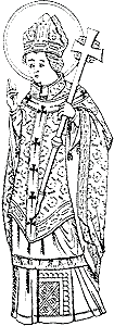
That is more often attributed to his son Deiniol (d.572
or 584), Celtic bishop in Gwynedd [Fig.
1] and founder of
Bangor (Caers.) with Bangor Isycoed as a daughter house. Dunawd
could not have been abbot at Bangor for long - much of his
life had been spent in arms earning himself the distinction
of one of 'the three Battle Pillars of Prydyn' up in Scotland
before retiring to end his days in his son's monastery in
the profession of religion. He was dead by 607A.D. |
| In referring to the Battle of Chester (about
616A.D.) when Aethelfrith of Northumbria took on and defeated
the men of Powys and Mercia, reinforced by a contingent of
superannuated monks from Bangor, Bede's narrative runs: "Most
of these priests came from the monastery at Bangor where there
are said to have been so many monks that although it was divided
into seven sections, each under its own abbot, none of these
sections contained less than three hundred monks, all of whom
supported themselves by manual work. About twelve hundred
monks perished in this battle and only fifty escaped by flight"
[4]. |
| Bede completed his History in 731, a century
after the demise of Bangor monastery almost 1400 years nearer
actual events than present-day commentators and some 411 years
earlier than that other 'chronicler' of Bangor, William de
Malmesbury, whose descriptions of the extent and magnificence
of Bangor's ruined monastic buildings are couched in terms
of twelfth century monasticism and are gross inventions. Dark
Age religious communities were just not like the rigidly ordered
and standardized Benedictine houses of Europe in the central
medieval period. |
| Bede's demographic statements, however,
must be treated with some scepticism - a concentration of
2,100 monks in any one Celtic mother church would be unique
in Wales. But the Triads go one better and specify 2,400
monks at Bangor [5]
Neither figure is credible and are so divergent from
the pattern of Celtic missionary work elsewhere e.g. under
1 kinsmen and contemporaries - Saints Cadfan, Seiriol and
Cybi - in Gwynedd as to be a complete anachronism. Such
numbers of people and densities are not to be encountered
in Wrexham Maelor until the latter half of the eighteenth
century when the Industrial Revolution was well under way.
Not even present-day Bangor Isycoed, in its role as
a rapidly expanding dormitory village to Wrexham, can match
these alleged Dark Age population statistics. Unfortunately
the only other indications as to size of Dark Age monastic
communities come from later Saints' Lives or Vitae for Gwynllyw,
Cwenfrwi (Winefred) and Paul of Leon) and the numbers are
very small - 7, 11, 12 [6]
Figures for Bangor probably and most sensibly
have to be trimmed to something approaching these proportions. |
| Such a move would have to be reconciled
with Bede's implied picture of a considerable settlement spread
over the flood plain of the Dee. In that it was 'self-supporting
by manual labour' one may justifiably consider the settlement
as being a focus for crafts and to some extent local trade.
In the absence of towns, other than Romano-British Chester,
Bangor monastery may be seen as beginning to display some
basic 'urban' characteristics. |
| If it difficult to conceive of a monastery
'divided into seven sections each under its own abbot' within
a single restricted area, it may be that Bede's words actually
hide a looser monastic federation i.e. outlying lands, churches,
communities dependent on the mother house. A 'sphere
of influence' may be discerned in the shape of adjacent dedications
and associations. Marchwiel and Worthenbury churches,
both dedicated to St. Deiniol, must be regarded as ancillary
to Bangor, or even as properties of that house - this in preference
to the more nebulous, incidental relationships that might
be construed from the emergence of a later medieval cult.
'Ffynnon Daniel [Deiniol] in the provostry of Pickhill and
Sesswick, 'Ffynnon y Saint' or 'Saint's Well' in Ruyton township
give further definition to former monastery property. Again,
as seen below, the '6 Crosses' noted by Edward Lhwyd may serve
to pin-point the varying 'zones of sanctity' about Bangor
monastery. |
| 'Tyddyn Daniel' in Bedwell
township (now Marchwiel parish) noted in 1562 may also be
connected with Bangor; but equally well 'Daniel may be just
the name of a medieval smallholder rather than 'Deiniol.
It is mere coincidence that in 1626 Tyddyn Daniel
was purchased and, according to the 1749 'Terrier' its rental
applied "to the repair and use
of the Church [Marchwiel]" [7] |
| Working on a principal that a federated
community would be confined to areas within easy reach of
the mother church - 50 or 60 miles, two or three days journey
- one could conceivably stretch Bangor's influence to Hawarden
(St. Deiniol's Church, Daniel's Ash) if not to Llanuwchllyn
(?Llanddeiniol uwch y Llyn) and LLanfor (?Llanddeiniol is
y Llyn). |
| To Bede the local historian owes the earliest
forms of the place-name 'Bangor As a simplex form 'Bangor'
means "a monastery, religious settlement, academy,
college (within a wattled fence)" in the sense of a
seminary of Christian teaching and learning, derived ultimately
from its basic meaning of a strong upper plaited rod in
a wattled hedge or fence for strengthening and binding the
same". |
| But interpreting 'Bangor' as applied to
Bangor Isycoed is more complicated than appears at first
sight as its earliest forms are complex, the final element
'bury' (OE burh = 'fortification, fortified place') being
lost only in the fourteenth century: |
Bancor 731 Bede Ecc. Hist. 100-102
Bancornaburg
Bankerbur' 1270 Cal. Charter Rolls II, 266
Bonkerbury 1278 Cal. Anc. Pet. 151
Baunkesbur' 1282 Cal. Welsh Rolls 226
Bankerbir' 1283 ibid. 271
Bankerbur' 1283 ibid. 272
Blanckebir' 1283 ibid. 262
Bankerburw 1291 Tax. Ecc
Bangor 1292 Flints. Lay Subsidy
Bangor 1309 Cal. Anc. Pet. 341 |
| In the light of the thirteenth century
forms it is tempting to see Bankebury as "a fortified
place on a bank" but the ODan, OE banke does not fit
in date-wise with Bede's forms of 731. In Bancornaburg
now shortened to Bangor we probably have something like
"the stronghold of the men of Bangor". Needless
to say one cannot envisage specially built 'fortifications'
in the late medieval sense as imagined by William of Malmesbury. |
| Assuming that the Bancor of 731 is not
an abbreviated form, it may be that the place-name forms
listed above actually have two separate concurrent strands,
the simplex Welsh Bangor used by Welsh speakers, and the
complex tautological form given and used by English/Mercian
colonists unfamiliar with the 'enclosure' significance of
Bangor and yet who, by appending burh or bury as a suffix
acknowledged in their own vocabulary and current terminology
the 'enclosure' element noted in site and physical aspect
of the monastery spread-eagled between high banks on the
flood plain of the Dee. One will recall that Bede
wrote "the monastery called in the lingua Anglorum
Bancornaburg", implying this was the form used by the
English and that there was an alternative form used by Welshmen. |
| It is interesting to note that in the
Old English Version oF Bede's Ecclesiastical History (Early
English text Society, (1890-8), III, 28) the element burh
glosses the Latin oppidum = 'town' (classical), 'castle'
(medieval) and 'a fortified wood in Britain' (Caesar). thus
another piece is added to the emerging picture of seventh
century Bangor as being a 'town' or substantial settlement
of some ecclesiastical importance. |
| About 1539 John Leland (1506-52), Library
Keeper to Henry VIII and later 'King's Antiquary' visited
Bangor. He had read the standard 'historiographies'
and monastic chronicles which account for an 'hearsay' element
in his narrative, but the latter also has pertinent things
to say about the local topography, in particular providing
evidence to the shifting within his lifetime of the course
of the middle Dee: |
| "This is Bangor where the great abbey
was. A part of this parish, that is as much as lies
beyond Dee' on the north side, is in Welsh Maelor, and that
is as half the parish of Bangor. But the abbey stood
in English Maelor on the hither and south side of Dee. And
it is ploughed ground now where the abbey was by the space
of a good Welsh mile, and yet they plough up bones of the
monks and in remembrance [i.e. in living memory] were dug
up pieces of their clothes in sepulchres. The abbey
stood in a Fair valley and Dee ran by it. The compass
of it was as a walled town, and yet remains the name of
the gate called Porthwgan by north and the name of another
called Port Clays [Porth Klais] by south. Dee since
changing the bottom runs now through the middle between
the two gates, one being a mile and a half from the other,
and in this ground be ploughed up foundations of squared
stones, and Roman money is found there" [8] |
| When Leland was writing the River Dee
had clearly changed course, if not recently, certainly within
human memory. Earlier, in his description of Overton
parish, he refers to the violent capriciousness of the river
which even then had washed away half of the motte of Overton's
twelfth century castle at Asney and was actively eroding
the remaining stump. |
| There is abundant cartographic evidence
above and below Bangor for the historic shifting of the
Dee's course and that of its' tributary, Worthenbury Brook
with its deferred confluence - abandoned and shifting meanders
that no longer coincide with parish/township/county/national
boundaries fixed post 1143 by reference to the Dee. This
gave rise to boundary anomalies that were only eradicated
with local government re-organisation in 1974. |
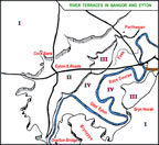
| There is also ample evidence for both
lateral and vertical movement of the Dee in the shape of
some remarkable river terrace development - and not just
peri- glacial features either.
[Fig. 2] The edges
of these terraces are noticed in the landscape by distinct
breaks of slope e.g. Bryn Hovah bank, Cock Bank, Eyton Bank,
and by eroded and weathered bluff lines Ruyton - Gerwyn
Fechan - Plâs-fron - Porthwgan. The lowest and
youngest terrace is given approximate definition by the
50ft. contour, its edges well marked below Plâs-fron
and, on the other side of the river, by the abrupt change
of slope that separates the track and fences of Bangor Racecourse
from the enclosures and car-parks and affords punters such
a natural uninterrupted overview of the running below. |
| At Plâs-fron bluff line and former
course of the Dee are emphasised and demarcated by the twisting
upper course of "The Foss", the stream that enters
the Dee below Upper Sesswick Bridge ('Pont Garreg'). Unfortunately
classical Latin fossa = "ditch, trench, channel"
and medieval Latin fossus "ditch, dyke, moat, embankment".
On the surface the name 'being so decidedly Roman'
(perhaps a back reference to the Foss Way and Foss Dyke
of Lincolnshire) early antiquaries promptly sited at Bangor
a Roman 'camp' and even the controversial BOVIUM of Itinera
II of the British section of the Antonine Itinerary the
third century Roman road list. Such attributions ignore
the fact that 'The Foss' is the Welsh ffos "ditch",
no more, no less, in this case a misfit water course
devoid of any historical associations [9] |
| It is possibly on the lowest terrace (III)
that the monastery at Bangor was situated. The present
Dee has incised itself several feet into this terrace, carving
out a fresh flood-plain and the wide meander belt carrying
such names as Ddol, Groes, Ddol Eyton etc. The meanders
are still actively prograding, or would be were it not for
modern extensive flood prevention works. To those
who seek, and have sought, in vain for traces of the monastery
one can only say: "It was here, but on an erosion surface
five or six foot above the present valley bottom". |
| The monastery would not be the only 'monument'
lost to the erosive powers of the Dee. In 1979 aerial photography
by Chris Musson revealed the remains of two Iron Age/Romano-British
farmsteads at Ruyton Farm [Fig.
3]. Flattened banks and filled-in ditches
show up as crop marks, except on the east side where farm-stead
boundaries have been lost to river terrace development,
the denuded break of slope being marked by linear
tree cover [10]
This may point to fresh terrace development taking
place in Bangor post-5th century A.D. |
| Please note:
All images on this web site are copyright, please
see copyright link for more information. |
|
|
|
|
St. Deiniol,
presumed founder of Bangor monastery, as portrayed in the
east window, north nave, of St. Teyrnog's Church, Vale of
Clwyd. |
—————— |
|
 |
|
 |
—————— |
NOTES ON SOURCES |
| [1]
L.A. Butler, 'The Monastic City in Wales : Myth or Reality",
Bulletin of the Board of Celtic Studies (1979) XXVIII, 458-467. |
—————— |
| [2]
Gerald of Wales, The Journey through Wales and the Description
of Wales (trans./ed. Lewis Thorpe, Penguin Books 1988), 251. |
—————— |
| [3]
E. Lhwyd, Parochialia &c. Part I. North Wales (Camb.
Arch. Assoc. 1909), 134. |
—————— |
| [4]
Bede, A History of the English Church and People (trans./ed.
L.Sherlev-Price, Penguin Books 1956), 100-102. |
—————— |
| [5]
R. Bromwich, Trioedd Ynys Prydein No. 91. |
—————— |
| [6]
S. Baring Gould & J. Fisher, Lives of the British
Saints Ill, 185-196, 234-241; IV, 75-86. |
—————— |
| [7]
Marchwiel Terriers in C.R.0. Ruthin date 1791-1856;
it would appear that the 1749 Terrier (see n.9 below for source)
is no longer extant. |
—————— |
| [8]
Spelling is modernised. L.T. Smith (ed. Itinerary of
John Leland &c (Centaur Press reprint 1965), III, 67-68. |
—————— |
| [9]
A.N. Palmer, "Notes on the Early History of Bangor
Isycoed", Y Cymmrodor (1890) X. 12-28. Reprinted 1991
by Bridge Books, Wrexham and bound along with Palmer's histories
of Holt, Isycoed, and Marchwiel. |
—————— |
| [10]
Archaeology in Clwyd 8 6. Fig. 3 is based on aerial
photograph CPAT 79-19-30. |
—————— |
|
|